Wednesday, July 23, 2008

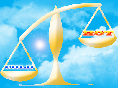
Did You Know that Cold Air is heavier than Warm Air?

Cold air is much heavier than warm air and this is the basis for much of what we call weather. Did you ever notice after taking a hot shower, that when you first open the door to the bathroom, the cooler air from outside the bathroom comes in at the lowest level? Or how about when you open your freezer, you could feel the cold air just rush downward towards the floor. Cold air in the atmosphere behaves the same way and this is why it stays separate from air that is warmer. Why is cold air heavier than warm air? Cold air is denser than warm air. The molecules are packed closer together. The amount of water vapor in the air also affects the density of the air. The more water vapor that is in the air, the less dense the air becomes. That is why cold, dry air is much heavier than warm, humid air. You may have heard that a baseball or a golf ball will travel further on a warm, humid day than it would on a cold, dry day. Since the warm, humid air is less dense, the ball travels through it with less friction. Please read my posts on cold fronts and warm fronts which describe how the different air masses interact and the weather that is caused by them.
Dave

Tuesday, July 22, 2008

Why the United States Ranks Number One in Tornado Frequency in the World

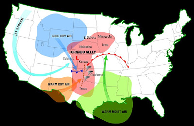
There is no other country in the world that has more tornadoes per year than in the United States of America. There is a huge supply of cool, dry air that comes down from Canada, warm moist air is readily available to come up from the south, and dry air is sometimes another ingredient that is almost always present in the southwestern states and in Mexico. That is what makes the U.S. the leader in tornado activity. There is nowhere else in the world that you have better conditions more conducive to tornado development than in the heartland of the U.S. The lack of any mountain ranges running west to east allows the cold air from Canada and the Arctic region to flow south and the warm air is free to flow north unobstructed from the Gulf of Mexico. The way the continent extends all the way into the Arctic allows the cold air masses to build and to extend southward, without being modified quickly by large bodies of water. The Gulf of Mexico provides the warmth and the moisture for these storms. The dry air from the southwestern states and Mexico is needed to produce the so-called dry-line, which causes numerous tornadoes and severe thunderstorms. Strangely enough, the dry air that infiltrates the low pressure center actually makes tornadoes more likely in certain situations. Upper level winds are very often favorable in "tornado alley" during the late winter and spring. Winds that blow from different directions at different altitudes can cause the spin necessary to produce a tornado. Note that tornadoes can form (and usually do) during any month of the year.

Why the mornings are normally less windy than the afternoons?

The reason is this. During the afternoon, the sun's heating is the strongest and this heating destabilizes the atmosphere. The sun heats the earth's surface, so the atmosphere is really heated from the bottom upwards. So, the air at the lowest level of the atmosphere is heated first. The warm air rises since warm air is lighter and less dense than the cooler air aloft. This "mixing" of the air helps to bring down stronger winds blowing at higher levels in the atmosphere. These stronger winds are blowing during the morning hours above the surface, but the air is many times too stable to allow the fast moving air to get to the surface. During the morning hours, an "inversion" is usually present which means that the lowest level of the atmosphere is cooler than the air aloft. This stable layer of cool air literally prevents the winds higher up in the atmosphere from mixing down to the surface. As soon as the sun heats the ground, this inversion begins to break down and the winds mix down to the surface. However, there are some exceptions: During stormy periods, the mornings can be just as windy as the afternoons. Also, if a strong cold front moves through your area in the early morning hours, the winds may be stronger immediately following the frontal passage and then die down in the afternoon or evening.

Why it's hotter during a drought?

Did you know that the dryness actually helps to add to the higher temperatures during a drought? How? In normal conditions, some of the sun's energy is used up to evaporate moisture in the ground, vegetation and other various surfaces. However, when the ground is extremely dry, the sun's energy that is normally used to evaporate this moisture in the soil, goes towards adding heat to the atmosphere. In other words, during a drought, nearly all of the sun's energy goes to making it warm instead of drying the ground and various surfaces.

Why is March such a windy month?

You may wonder why March is such a windy month compared to the other months of the year. While there are several reasons, I will highlight the major reasons. The extreme contrast in temperatures causes major storms to develop on occasion. Cold air masses can be every bit as cold as they were during the middle of the winter. The barometric pressure in the core of these air masses increases to very high levels. At the same time, the increasing sunshine over the temperate zones produces warm air masses to begin developing and moving north. The low pressure areas combined with departing high pressure areas produce the southerly winds that bring this warm air in contact with the still very cold air that dives down from the north. The pressure differences between the strong high pressure areas and the deep low pressure areas make for some windy days in March. Another reason it is windy in March is the increased atmospheric instability caused by the increasingly strong sunshine. This heats the earth's surface and since warm air is lighter than cold air, the air rises. This process results in more "mixing" of the air, which tends to bring down the stronger winds from the upper atmosphere. The very different air masses that move into the U.S. cause the huge fluctuations in temperatures making one day feel like summer and the next day feel like winter. Once we get into the month of April, the cold air masses moderate and while there could still be some large contrasts in temperatures and large intense storms, the warm air begins to start winning the battle. Note that November tends to be a windy month also, as we see the extra-tropical storms begin to strengthen and the difference in air mass temperatures increase.

Why is fog more common during the fall?

Foggy mornings are much more common as we head into the autumn months and the reasons are quite simple. The nights are getting longer and longer which allows the temperatures to fall to the dew point. As the air cools, it cannot hold as much water vapor so the water vapor condenses into tiny moisture droplets that stay suspended in the air. This is what we call "fog". (See my weather fact on the dew point and why it is so important). The month of October can be especially foggy across Southeast Virginia, especially during the morning hours. October usually is the foggiest month of the year throughout most of the Mid-Atlantic region. Humidity levels can sometimes still be quite high during October. Once we get into the latter part of fall, humidity levels drop and there is a tendency for higher wind velocities. Therefore, the frequency of foggy mornings starts to decline on average. In Southeast Virginia, fog can occur at any time of year but it is far more likely in the fall. Note that during the early spring, coastal areas experience fog on occasion which is caused by the cold ocean waters cooling the air above the surface to the dew point. This phenomenon usually occurs later in the day through the mid to late morning hours, when the sun is less intense. This fog normally dissipates as it heads inland.

Why is August the most humid month of the year in Hampton Roads?

Did you ever wonder why the humidity levels in August are so high? The reason is that the ocean temperature reaches its peak in August, which is usually around the 80 degree mark off of Virginia Beach. The warmer the temperature of the water is, the more water vapor evaporates from the surface of the water into the atmosphere, thus raising the humidity levels. The warm water temperature in August lessens the cooling effect of a sea breeze or a gradient wind coming from the ocean. In June, a breeze off the still cool ocean can bring much needed relief to coastal areas. However, in August, the cooling effect of a sea breeze lessens for two reasons. 1) Since the water isn't as cool as it was in June, the air temperature will not drop as much 2) Since the water is warmer and the evaporation rate is higher, the dew point will actually be higher right along the coast.

Why does a heat wave sometimes follow a cool spell in the spring and early summer?

While strange but true, many a heat wave has come on the heels of a cool spell in the Mid-Atlantic Region. The reason is that the same cool, Canadian high pressure area that brings in the cool air moves off the east coast and then pumps up warm air on its back side. Remember, winds blow clockwise around high pressure areas in the northern hemisphere, so as the high settles off the east coast, winds turn southwesterly, and this brings in the warm and sometimes humid air. A very notable example of this occurred in April 1976, when the temperature reached 96 degrees on April 18th in NYC after a cool spell a week earlier.

Why does autumn have more foggy mornings in inland areas than any other season of the year?

The main reason is the increasing length of darkness. This increases the time of radiational cooling thus causing the temperature to fall below the dew point. That is how fog is created. Warm air can hold more water vapor than cool air, so as the air cools overnight, the water vapor condenses into small droplets that are suspended in the air. This is what causes fog. You've probably noticed that during fall there is more dew on your vehicle than any other season. The temperature of the surface of your vehicle is normally cooler than the air, so condensation occurs on most mornings. Note that during the winter and spring, fog can be more common along coastal areas because the cool ocean waters cool the air below the dew point. This fog can blow inland on some days.

When is the Peak of Hurricane Season in the Atlantic?

Based on averages since records have been kept on hurricanes, the peak of hurricane season is September 10th. On this day, the chance of there being a tropical cyclone spinning somewhere in the Atlantic Basin is the highest. Hurricane season begins June 1st and ends on November 30th. Tropical cyclones can occur outside of hurricane season, but they are quite rare.

*Image: NOAA

When is it Warmer Near the Water?

On many days during the spring and summer months, you hear meteorologists say that the air temperatures will be cooler near the water. That is simply due to the fact that the water temperature is cooler than the air temperature during the spring and summer afternoons and when the wind blows from the water, it will be cooler near the shore. (See my weather fact on "Sea Breezes") However, during the fall and winter months, there are many mornings when the air temperature is warmer in the late night and early morning hours near the shoreline. That is because the water temperature is warmer than the air temperature on some occasions. This is especially true when arctic air masses move into the region. That is also why the date of the first killing frost is normally later near the Atlantic Ocean and Chesapeake Bay than it is away from the water. The reason for the temperature differences between the inland areas and the coastal region is that water takes much longer than land to heat up and to cool down. Keep in mind that the wind direction plays an important role in this process. On mornings when strong winds are blowing, there probably won't be that much of a temperature difference between inland and coastal areas.

When does the Cape Verde season begin?

The Cape Verde season, which is when tropical cyclones form in the Eastern Atlantic, begins around the 15th of August. At that time, upper-level winds and sea surface temperatures usually are right for storm development. Since these storms move across a large part of the Atlantic, they can become monster storms as they move westward. However, sometimes they turn harmlessly out to sea if there is a weakness in the vast high pressure system that extends to the stormís north. Other times, they move towards the Caribbean Sea, Gulf of Mexico, or the East Coast of the U.S.

*Image owned by NOAA

What was the only Tropical Storm that had its name retired?

It was* Tropical Storm Allison that flooded the Houston, TX area in June of 2001. Rain amounts were absolutely incredible with this storm. Thirty-seven (37) inches of rain fell in one hard hit area. The storm killed twenty-two (22) people as it just stalled in one area and unleashed heavy rains for days.

Katrina has been added to this list.

What is Virga?

Virga is precipitation that evaporates before it hits the surface of the earth. Virga is actually very common and can occur at any time of the year. Normally, it is a result of a dry lower atmosphere. Initially, when precipitation begins to fall from the thickening clouds as a low pressure area approaches, the light precipitation will evaporate as it falls to the earth. This process does two things. It moistens up the lower atmosphere and it cools the lower atmosphere from evaporational cooling. As the low pressure area (or warm front) move closer and the precipitation gets heavier, it eventually reaches the ground. Sometimes you could actually see virga. On certain days, when there is a lot of vertical instability in the atmosphere, you will have large cumulus and cumulonimbus clouds that can produce precipitation but it never hits the ground. And due to the normally good visibilities on days like that, you could actually see the precipitation under the base of the clouds against the blue sky in the background and then it fades away as it falls to the ground. The precipitation will appear like a veil of gray hanging from the cloud.

What is the jet stream?

The jet stream is a river of fast moving air high in the atmosphere. It's normally near the boundary between the troposphere and the stratosphere (tropopause). It normally blows at speeds between 110 and 140 knots. The jet stream normally is situated in the middle latitudes. During the winter months, it usually blows across the U.S., undulating back and forth. During the summer, it lifts north well into Canada. Once in a while, the jet stream does unexpected things like dive far to the south in the spring bringing unseasonably bitter cold to parts of the U.S. On rare occasions, it can go far to the north during the winter, causing mild winter weather in the U.S. The jet stream can normally be found between the tropical air masses and the polar air masses. The jet stream is responsible for causing mid-latitude storms to intensify rapidly. It can also cause spring and summer thunderstorms to grow stronger and severe. The jet stream is responsible for moving weather systems along. Jet airliners can take advantage of the jet stream to travel faster west to east such as a flight from New York to London. They try to avoid it when they are going the opposite direction.

What is the wettest month of the year on average in Norfolk, Virginia?

Many people might be surprised that the wettest month of the year in Norfolk, Virginia is July, with August being a close second place. It may seem like one of the winter months is wetter since we do have plenty of damp, dreary, cloudy days during the cooler months of the year. However, it's the summer storms that drop the most rain. A thunderstorm can easily drop several inches of rain in a very short period. During the winter, the precipitation is mostly light to moderate in nature. The other significant factor is tropical cyclones and their remnants. Hurricane season runs from June 1st through November 30th. The heavy rainfall associated with those systems increases the overall averages during the summer. Even if we don't get hit directly from a tropical cyclone or its remnants, the moisture that sometimes is brought into our region from a tropical cyclone enhances rainfall amounts under certain weather conditions. It's the overall weather pattern during the summer months that brings in copious amounts of moisture from the tropical Atlantic, Gulf of Mexico, and the Caribbean Sea. The Bermuda High is largely responsible for pumping in this moisture. In July, we average over four and a half inches of rain. November and December are our driest months here in the Hampton Roads area as they average less than three inches of precipitation.

What is the Low Level Jet?

You may have heard or seen the term "low level jet" used in the forecast discussion. This term is used to describe a wind flow just above the surface at night which can cause and enhance thunderstorm development during the spring and summer months. It's a very complicated process that occurs but in a nutshell it can be described as follows: At night, the cooler air sinks and collects at the surface of the earth. If there is a gradient wind flow and it is warm and has adequate moisture, it will rise above this stable layer near the ground. This rising motion and faster flow causes the lift and needed instability which can result in heavy nighttime thunderstorms. They normally dissipate during the morning hours.

What is the Dew Point and Why is it so Important?

Youíve probably heard meteorologists talk about the dew point and you wondered what impact that it has on the weather. The dew point is very important in many ways. It affects whether you will have to clean the frost off your windshield in the morning. The dew point determines how uncomfortable you will feel on a warm summerís day. It determines whether it will rain or snow. The dew point determines how high the danger is for a grass or brush fire during a dry spell. Thatís just a few reasons why it is so significant. The definition of dew point is as follows: The dew point is the temperature at which the moisture (water vapor) in the air begins to condense. The warmer the air is, the more moisture it can hold. I always use the glass of water comparison to explain this. Letís say you have two glasses, one large the other small. Since warmer air can hold more water vapor, the large glass represents the warm air. If you fill the smaller glass (which represents the cold air) to 90% full and you pour it into the larger glass, the percentage of water in the larger glass will be much less than the small glass was. Since the opposite will be true, letís say that the large glass was 90% full and you poured the water into the smaller glass. It will overflow, wonít it? That overflowing represents condensation, when the air just cannot hold the water vapor in its invisible gaseous form and it turns into visible water droplets. You can literally see the dew point in action during cold, damp weather. When you breathe out, the air coming out of your lungs is very warm. As this air hits the colder air outside your body, the invisible water vapor immediately condenses and you see the ìcloudî in front of your face. Why does it condense? The colder air cannot hold the water vapor and it releases it immediately. This ìcloudî consists of tiny drops of moisture that are suspended in the air. In the real clouds in the sky, itís the same principle. On a summer day, when the sun heats the ground, the air immediately above the ground also warms up. Since warm air is lighter than cold air above it, it rises into the sky. As it rises, the air cools until it reaches the temperature that it can no longer hold the water vapor. That temperature is the dew point. Then, a cloud forms. You might askÖ Why does dew (or frost) form on my car but there is no fog? The reason is that the temperature of the surface of your car is cooler than the surrounding air and yes, it has to be at or below the dew point even though the air is not at or below the dew point outside. Once the air temperature reaches the dew point, fog will form. The reason the dew point is important during the warmer months is this. When you perspire, the water on your skin evaporates and cools your body. This is the bodyís natural temperature regulating system at work. When the dew point is high, the evaporation rate is very slow because there is so much water vapor in the air, and you donít get the cooling effect from your wet skin. The dew point also affects how you feel when you get out of a pool, lake or the ocean. On those days when the dew point is very low, you will feel cooler than when the dew point is high. This is because when the dew point is low, the water on your skin evaporates faster thus cooling you off. I hope this explanation helps you understand the importance of the dew point.
What is the Bermuda High?

The Bermuda High is a high pressure area that is usually centered in the vicinity of Bermuda during the spring and summer. This high pressure area is responsible for the prolonged heat waves in the Eastern part of the country. Since winds blow clockwise around high pressure areas in the northern hemisphere, a south to south-westerly wind transports heat and humidity into the Mid-Atlantic States. During the late spring and summer, cold fronts from the north and west have trouble making inroads into the Hampton Roads area due to the persistent Bermuda Highís influence. The high migrates east and west which causes fluctuations in our weather. There are times when it builds westward and is configured in such a way to change our winds to a south-southeasterly direction. This sometimes brings in a tropical air mass and lots of moisture. The interaction of the warm moist air moving over the land causes shower and thunderstorms that can dump copious amounts of rain. Two factors cause the air to rise. The friction of the land and the heat from the land causes the air to rise high into the atmosphere, This causes condensation which then leads to showers and thunderstorms. The position of the Bermuda High also is a player in steering tropical cyclones towards the west and then northwest. If the high is further out in the Atlantic, the odds are that the cyclones will curve and go out to sea. If the high is further west, there is a good chance that the cyclones can impact the East or Gulf Coasts of the United States.

What is an Isobar?

An isobar is a line on a weather map that connects points of equal barometric pressure. The map is sometimes called a ìCurrent Surface Analysis Mapî. The closer these lines are packed together, the windier it will be in that particular area. Many times during the colder months of the year, you will find a low pressure area over the North Atlantic surrounded by numerous isobars and you can bet that it is extremely windy near that low. Ask any mariner who sails through those storms. During the warmer months of the year, lows arenít as intense, so you wonít normally see that many isobars packed closely together. That is why the summer months are not normally that windy in most of the U.S. However, there is one exception and that is the hurricane. Isobars right around the eye of a hurricane are incredibly close together.

What is a Sub-Tropical Storm?

Sub-Tropical Storms are actually a fairly new designation of ocean storms that have some tropical characteristics, but are not truly tropical cyclones. Years ago, they werenít recognized by the National Hurricane Center (NHC). Lows were either extra-tropical or tropical cyclones. However, there was strong pressure on the NHC from several meteorologists to designate certain storm systems as sub-tropical since although they werenít truly tropical in nature, they did have some characteristics of a tropical cyclone and they caused more problems than extra-tropical storms. What makes a storm tropical? It has to be a ìwarm coreî system. That is, temperatures warm as you head towards the center of the storm. The processes that create the clouds, winds, and rain in a warm core system are different than an extra-tropical storm, which is your everyday cold season low pressure center. Warm core systems donít have fronts and donít need a difference in air masses to cause the pressure to lower or precipitation to form. Warm core systems depend on the warmth of the ocean for their energy. The warm, moist air evaporates from the ocean. Since this air is lighter and more buoyant, it rises into the atmosphere and condenses into clouds as it cools. The condensation process gives off latent heat which further accelerates the rising air. Sub-tropical means that the storms have the same processes that tropical storms do to create the lowering pressures and the rainfall, but they also have some of the processes that the cold core systems have, such as fronts and baroclinic processes due to the different air masses.

What is a Nor'easter?

What is a Nor'easter?
Nor'easters are low pressure areas (extra-tropical storms) that develop along the southeast coast and move northeastward along the coast bringing copious amounts of rain and/or snow to the eastern seaboard. (Some folks call them "Northeasters") They normally occur from October through April, but they can occur outside of that period. The reason that these storms are sometimes so severe is that they draw their energy from several sources. First, the difference in temperature from northwest to southeast during the colder months of the year is quite extreme along the east coast. Second is the Gulf Stream, which is the ocean current off the east coast that brings warm water northward. The Gulf Stream enhances the east coast storms, as it provides the energy and moisture needed for the storm to grow into a monster and it causes a large temperature gradient near the east coast. Large areas of precipitation develop to the northwest, north, and northeast of the low center. Noríeasters are responsible for producing the blizzards from the Mid-Atlantic States through New England. Winds can gust to hurricane strength during intense Noríeasters. Coastal flooding and beach erosion usually occur which can cause property damage. The exact track of a noríeaster determines the precipitation type and how bad the storm will be in a given area. However, to be a true noríeaster, the storm has to move along a northward or northeastward track just east of your location. If the storm moves to the west of your location, the winds may be out of the northeast initially, but your winds will turn to the southeast and eventually the southwest as the storm gets closer. There are several different scenarios on the weather map that cause these storms to develop. I wonít go into the technical details, but they can be from lows that start developing in the Gulf of Mexico and then move to a position off of the southeast coast. Some noríeasters develop as energy is transferred from a weakening storm moving through the Ohio Valley. The energy transfers to the coast and then the storm ìbombsî, which means it intensifies rapidly when it ìfeelsî the effects of the Atlantic Ocean. Upper level winds must be favorable for a nor'easter to form and to grow into a major storm. In 1998, the Hampton Roads area was impacted by two noríeasters causing very high tides, coastal flooding, and severe beach erosion. Winds were very strong during those storms. The March 1962 noríeaster is probably the worst storm of its type to hit the Mid-Atlantic area in recorded history.

What Does Wind Direction Mean?

When meteorologists talk about wind direction, does it mean the direction the wind is blowing from or blowing to? The answer isÖWind direction is where the wind is coming from. If the weatherman (or weatherwoman) says that the wind is southwesterly, that means that the wind is blowing FROM the southwest.

What does Bombogenesis mean?

If you live along the east coast of the United States, you may have heard a meteorologist say that a storm system or low pressure area is ìbombing outî or that bombogenisis is about to occur. What do these terms actually mean? When a low pressure system or mid-latitude cyclone moves off of the East Coast of the United States during the colder months of the year, there is a tendency for many of them to intensify rapidly due to the warmer waters of the Gulf Stream and the positioning of the low between two very different air masses. The air mass to the storm's north and west is usually very cold and dry while the air mass to the storm's south and east is very warm and moist. The stormís rapid intensification is known as bombogenesis or I've heard meteorologists say that the storm is ìbombing outî. The heat given off by the ocean is like fuel for the storm. Barometric pressure can drop rapidly causing the winds to increase rapidly. This is the reason noríeasters grow very strong and wreak havoc on the east coast. The warm moist air is extremely plentiful off the southeast coast. This energy feeds into the developing storm via the warm sector of the low. The warm air then rises as it encounters cooler air to the north. This rising motion causes condensation (clouds) to occur which then leads to precipitation. The condensation process actually creates heat (latent heat) and this process further adds ìfuelî to the stormís energy. Upper level winds and conditions also add to the intensification process. If you look at a surface analysis map with the isobars, which are lines that connect equal barometric pressure, you will see that the lines are packed closely together in a storm that is bombing out. This indicates that the pressure gradient is steep and that the winds are strong. These storms sometimes produce hurricane force winds and they cover a large piece of real estate, extending farther than even the largest hurricanes.

What Causes Wind?

Wind is caused by the difference in pressure from one point on the earthís surface to another. The air moving from the area of higher pressure to the area of lower pressure is called wind. The air does not move directly from the point of highest pressure to the point of lowest pressure. The earthís rotation affects the air flow by deflecting it to the right. This effect is called the Coriolis Effect. In the Northern Hemisphere, this causes air to flow clockwise around high pressure areas and counter-clockwise around low pressure areas. Now, you may ask ìWhat causes the difference in pressures on the Earthís surface?î The answer to that is quite complex so I wonít go into great detail here. Generally, you could say that the cause of the difference in pressure across the globe is the uneven heating of the Earthís surface from the sun. This is due to several factors. Land warms and cools much faster than water. And, of course, latitude affects how much solar radiation is received each day and returned to space each night.. In addition, topography has an effect on solar radiation. Even the types of vegetation affect how much sunlight is absorbed and reflected. Snow cover plays a major role in absorbing solar radiation. Snow cover reflects a huge amount back to space. As air cools over the northern latitudes, it sinks to the surface and the air pressure increases. This results in the huge arctic high pressure areas that frequently develop over Canada. There are other elements that influence the amount of solar heating distribution, but these are the major ones. High pressure and low pressure areas form due to these factors and the battle zones that form between the air masses (the fronts) create the low pressure areas. The pressure gradient or the difference in pressure over a certain distance, determines the strength of the wind. As warm air rises in the developing frontal system (or extra-tropical storm), air pressure drops. Then, surrounding air moves in at the surface to replace the air that has risen. This is called "wind". This flow of air is deflected to the right by the Coriolis Effect. This is a very simplified way of explaining a very technical process that goes on to create a storm system. Now, tropical storms and hurricanes produce wind by lowering air pressures in the center of the low pressure area. The pressure gradient is more extreme in these storms since the difference in pressure is greater over a very short distance (between the center or eye of the storm to the outer edge of the stormís circulation). There are localized wind systems, such as "sea breezes". (Please see the weather fact I added explaining sea breezes in detail).

What causes thunderstorms in the Hampton Roads area?

The average number of days with thunderstorms in Hampton Roads is about 40 days annually. Why do thunderstorms occur and what months are we more likely to see one? Iíll try and answer these questions but keep in mind that there are a great number of complex factors that go into thunderstorm development. I will try to keep it simple so everyone gains an understanding of this process. June, July, and August are the peak months for thunderstorm development here in Southeast Virginia. It is the time of year when humidity levels increase, sunshine is at its peak intensity and as a result, thunderstorms become more numerous. All that is needed is a ìtriggerî in the atmosphere. What acts as a trigger? Cold air aloft (upper-level disturbance), a jet max, a frontal boundary, a sea breeze, a low level air stream or low-level jet (night-time only), etc, etc all can act to cause a thunderstorm. Forecasters have a tough time forecasting who will see one on any given day. It is really impossible to determine what part of Hampton Roads will see a storm when they are isolated or scattered in nature, which happens quite frequently. Thunderstorms can be the pop-up or garden variety as they are called. They can come in squall lines, which happens more frequently in spring. The basic cause of thunderstorms is the instability in the atmosphere, which is caused by warm, moist air at the surface rising up into a cold upper atmosphere. Warm, moist air is much lighter than cold air so it rises. The cold air cannot hold as much water vapor in its invisible state as the warm air, so the water vapor condenses into clouds. These clouds are called cumulonimbus clouds. They are large puffy clouds that tower up high into the atmosphere. The water droplets or ice crystals that make up these clouds collide together and grow larger and heavier. They eventually fall in the form or rain. Note that sometimes they fall as hail. (See my weather fact on the hail for more details). The tops of the clouds get blown into an anvil shape by the upper-level winds in mature thunderstorms. Thunderstorms produce very heavy rainfall rates and this is why July and August are Hampton Roadsí wettest months of the year. Sometimes, high winds result from these storms. There are two reasons for the strong winds. The heavy rain and/or hail cools the lower atmosphere rapidly and this cooler, denser air falls towards the ground. When the air hits the ground it spreads out rapidly. That is why so many thunderstorms are preceded by strong winds which are much cooler than the air that was there to begin with. Strangely enough, this cool air that they generate helps to destroy the storm, since thunderstorms need warm, humid air in the lower layers of the atmosphere to sustain themselves. The other reason for the strong winds is that sometimes thunderstorms help to bring down strong upper-level winds to the surface. This happens more frequently in the early spring, when the jet stream is stronger and further south. Of course, I canít forget about the lightning and thunder. Lightning is a very dangerous weather phenomenon. The electrical charges change due to the heavy precipitation and this causes the conditions necessary to cause lightning. Lightning is a killer and it can destroy property. If you hear thunder, look for shelter immediately. I hope that this weather fact has given you a better understanding of thunderstorms.

What causes thunder? What causes thunder to rumble sometimes and why does it sound like a crack or bang at times?

Thunder is caused by the rapid heating (and then cooling) of the air from lightning. Lightning is exceptionally hot so when it passes through the air, it heats the air very rapidly. This heat causes a rapid expansion of the air column followed immediately by rapid contraction of the air column due to the air cooling back down. This sends out a shockwave through the atmosphere, which results in the sound that we refer to as thunder. If the lightning hits close by, the thunder will sound like a crack or bang. If the thunder is caused by lightning that is far away, it will rumble and slowly fade away. The reason that it rumbles for a long time sometimes is this... At first, you are hearing the sound created by that part of the lightning that is closer to you. Then, as each passing second goes by, you are hearing the sound of the parts of the lightning that is further and further from you. This is especially true when the lightning is cloud to cloud, which means that it is nearly horizontal, relatively speaking. Lightning can stretch for a long distance so you can understand why the thunder can last for quite a while from one lightning strike. When cloud to ground lightning hits close by, it is vertical for the most part, which means that much of the sound will get to you about the same time. In other words, a large part of the lightning strike is roughly the same distance from you when it is mostly a vertical (or cloud to ground) strike, so you hear much of the sound, or the thunder, at the same time. This is when the thunder sounds like a crack or a bang and it can be especially loud. You should always take cover when you hear thunder, especially when it is loud and sounds like a bang.

What causes a drought like the exceptional Southeastern Drought of 2007?

Droughts are not headline grabbers like tornadoes, blizzards, hurricanes, heat waves, etc. They are slowly building events that will make the news once water levels reach critical levels or farmers suffer crop losses. Droughts can have more of an overall impact since they last so much longer than the other events. There are several reasons why a drought occurs. Iím going to describe the drought of the Southeastern United States which has peaked in 2007. The Southeast normally receives some of its yearly rainfall from tropical cyclones or the remnants of these storms. During 2006 and 2007, very little rainfall was attributed to tropical cyclones. More importantly, a persistent high pressure ridge has been present over the Southeast. This ridge has several names. Iíve seen it referred to as the Great Smokies Ridge, The Southeastern Ridge, for example. This high pressure ridge has caused subsidence in the atmosphere and has prevented widespread, frequent rainfall which normally occurs over the Southeastern states. It has also prevented low pressure areas from approaching the Southeast and has steered them west up through the Mississippi Valley. Alabama has been especially hard hit as well as Georgia, North Carolina, Virginia and Tennessee. Another reason for the drought is the lack of low pressure storms (or extra-tropical cyclones) during the colder months of the year. Normally, low pressure areas develop near the Gulf States and they move eastward or northeastward through the Southeast dumping huge amounts of rain. There havenít been many such storms during 2006 and 2007. La Nina plays a role in the dry weather pattern as it changes the weather patterns across North America. La Nina is a term used for the unusually cold water temperatures of the Eastern Pacific near the Equator. Some effects of the drought are as follows: Lake levels have dropped drastically, river levels have dropped to record lows, water supplies are threatened, trees are suffering, wells dried up, crops have failed, etc, etc. Is this drought caused by global warming? That is a question that really cannot be answered right now.

Water Vapor, the Natural Greenhouse Gas

Water vapor is one of the most effective greenhouse gases in our atmosphere. It is truly the most significant gas that holds the heat in. That is why those humid nights during the summer are warmer than the clear, dry nights. When the air is dry, the heat is allowed to escape into space quite rapidly. On humid nights, the water vapor in the air literally keeps the heat in only allowing small amounts to seep into space. That is why the temperature in a desert can range from over 100 degrees during the afternoon to close to freezing in the morning. The heat gained during the day just radiates back into space overnight. Most of the water vapor that is in the atmosphere occurs naturally. Only a very small amount is as a result of human activity.

Warm Fronts and Cold Fronts - A Brief Explanation as to How Precipitation Varies with Each Type of Front

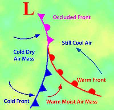
Warm Front - A warm air mass is overtaking a cold air mass. Since warm air is less dense than cold air, it rises above the retreating cold air. Warm fronts normally have a gradual increase in cloudiness. First, high clouds move in from the southwest and then begin to lower and thicken. Then, light precipitation begins to fall and it gets steadier and heavier. In the warmer months of the year, thunder and lightning is possible. During the winter months in some parts of the country, snow may fall as a warm front approaches but it usually turns to sleet and then rain as the front gets closer and the temperatures increase. Freezing rain is also a possibility. After the warm front passes by, the weather usually clears and becomes warm.
Cold Front - Cold air is overtaking warm air. Since cold air is denser than warm air, cold air undercuts a warm air mass. This produces a more concentrated line of heavy precipitation as the push of the cold air literally lifts the warm air just ahead of the front. This lifting of the air many times causes thunderstorms or very heavy showers. The increase of cloudiness preceding a cold front is usually rapid. The clearing behind the front is sometimes rapid, but there are times when the clearing is very slow after the front passes. This is when the cooler air mass is shallow behind the front. Also, there are times when a cold front and a warm front do not have any precipitation associated with them.

The Sea Breeze

Have you ever been on the beach and all of a sudden the wind shifts from off of the water and the temperature drops quite drastically? This sudden shift in wind which can be quite refreshing during spells of hot weather is most likely the result of a sea breeze. Sea breezes keep coastal areas cooler in the spring and summer on many, but not all days. What causes the sea breeze? It is really quite simple. Land heats up faster than the water. The air over the land begins to warm and since warm air is less dense than cool air, it rises as it is lighter than the cooler air above it. As the warm air rises over the land, the cooler air over the water begins to move in to replace the air that is rising over the land. This causes the wind at the surface to switch direction and blow from the water. As the afternoon wears on, the sea breeze normally strengthens and moves further and further inland. Its cooling relief can sometimes be felt many miles inland. Once the sun sets, the air over the land begins to cool and the air stops rising. The sea breeze stops blowing and many times reverses itself and becomes a ìland breezeî as the night wears on. The land cools rapidly at night and the air begins to descend. If the normal gradient wind between the high and low pressure areas on the weather map is blowing from the land, it will resume at night. Even if there isnít much of a gradient wind, a light ìland breezeî normally develops as the air moves out over the relatively warmer water. Some days, when the winds are blowing quite strong from off the land, a sea breeze will not develop. It takes certain conditions to produce a sea breeze. Note that sea breezes can enhance thunderstorm development as they produce a ìsea breeze frontî. This is where the cool, ocean air meets the opposing air flow as the sea breeze heads inland. This causes additional lift in the atmosphere, which can cause thunderstorm development. Sea breezes can raise humidity levels which can offset the cooling effect that they will bring to coastal communities. Most of the time, they are welcome relief to anyone living along the coast.

The Occluded Front

An occluded front occurs when a cold front overtakes the warm front in a low pressure storm system or an extra-tropical storm. This usually happens when the storm reaches its peak intensity. In most cases, the low pressure storm system will slowly begin to dissipate once this happens since the warm air source is being cut off from the center of the storm. The low pressure area will then fill and the pressure will slowly rise. Precipitation will diminish and the winds will lessen. This process can take several days. The front is represented on a map with both the triangles of a cold front and the semi-circles of a warm front. They appear on the same side of the front and are always on the side that the front it moving towards. A ìstationary frontî has the triangles on one side and the semi-circles on the other.

The Difference Between Meteorological Winter and Astronomical Winter

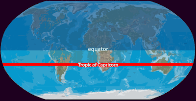
Meteorological winter is a three month period that runs from Dec 5th to March 5th. It is the coldest three month period of the year in the northern hemisphere. Astronomical winter is what we all refer to when we talk about the winter season and this is based on when the sun reaches the most southern point on the globe, the Tropic of Capricorn. If you are located right on the Tropic of Capricorn at 12:00 noon on the first day of astronomical winter, the sun will be directly overhead. Also, on the first day of astronomical winter, the sun is at its lowest point in our sky at 12:00 noon and, of course, it is the shortest day of the year. Obviously, it is the first day of the summer season in the southern hemisphere.

The Difference Between Hail, Sleet, and Freezing Rain

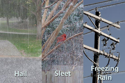
Many times I hear people say during a winter storm that it is hailing. This is actually called sleet. Hail normally occurs in thunderstorms and is the result of strong updrafts that repeatedly carry growing chunks of ice upwards into the clouds. Once the hail stones become too heavy to be lifted by the updrafts, they fall to the ground. Hail stones are normally much larger than sleet pellets and they can cause damage to crops, windshields, people, etc. Sleet occurs during a winter storm and is caused by rain falling into a cold layer of air aloft which has to be below freezing. As the raindrops fall through the cold layer of air, they freeze and become small ice pellets. When they hit your car windshield or your windows at home, they can make quite a racket. Sleet can accumulate on the roads and sidewalks making driving and walking quite hazardous. Freezing rain is basically rain that falls onto the ground and then freezes AFTER it hits the ground. It causes a glaze of ice on trees and any surface that is below freezing. Freezing rain causes the most hazardous of driving and walking conditions. Freezing rain is what causes the power outages as a result of the ice that forms on the trees and power lines making them so heavy that they come down. A temperature inversion causes the conditions that result in freezing rain. This means that it is warmer aloft than it is at the surface.

The Backdoor Cold Front

During the spring and summer months, you may hear the term "backdoor cold front" used by meteorologists in our area. Most cold fronts arrive from the northwest, but some come in from the northeast they are the "backdoor cold fronts". Every so often, a high pressure area will develop over New England or off the coast of the Northeast. Since winds blow clockwise around high pressure areas in the northern hemisphere, the wind will blow out of the northeast around the high pressure area. The air will pass over the chilly water off the coast of the Northeast and Northern Mid-Atlantic States. As this cooler air moves down the coast, it produces a cold front which can drop temperatures drastically due to the still cold water temperatures in the spring. Since the fronts come in from the northeast and not the northwest, the term "backdoor" is used. Many a heat wave has been broken from these types of cold fronts. Temperatures can drop from the 90s to the 60s just like that. The ocean temperature will play a big role in what the temperature will drop to once the front moves through as the wind switches to the northeast. During the late summer, the back door cold fronts become less and less frequent. That is due to several factors, most notably the increase in water temperature and the weather patterns across the North American continent. Sometimes, back door cold fronts produce showers and thunderstorms, but they are not noted for producing widespread severe weather. They usually lack the dynamics in the upper atmosphere to produce severe weather. However, when it is very humid preceding the front, heavy rain can result from these fronts. Every so often, during the early spring, some sea fog will blow in after the passage of a backdoor cold front right along the coast. Low clouds from the ocean can penetrate inland several miles.

The Alberta Clipper

What is an Alberta Clipper? It is a low pressure area that develops usually in the Alberta Province of Canada and it moves rapidly southeastward towards the east coast. The fast movement gives it the name "clipper". These storms usually bring snow to the northeastern states, but many times moisture is limited with these systems as they don't have time to tap the Gulf of Mexico for its rich supply of moisture. (The low pressure areas are usually too far to the north) However, every once in a while, these storms intensify rapidly along the east coast and drop heavy amounts of snow in the northeastern states. That is when the weather pattern enables the storms to tap Atlantic moisture. Sometimes, a secondary low pressure area develops off the coast and enhances the precipitation. They usually don't bring significant snow to the Hampton Roads area. However, every once in a while, the Alberta Clippers take a track far enough south dropping some snow in our inland areas. They usually develop when the weather pattern is on the cold side east of the Rocky Mountains and the upper-level winds are blowing out of the northwest.

Summer and Winter Precipitation Amounts: A Comparison of the West and East Coasts of the United States

Believe it or not, the summer is our wettest season here in the Hampton Roads area. While in California, the winter is the rainiest season. You might find it hard to believe that we receive more precipitation here in the summer than the winter but here is why. Rainfall during the summer is primarily from thunderstorms and they can produce a lot of rain in a short period of time. Also, tropical cyclones and their remnants add to our rainfall totals during the summer months. We all know how heavy rainfall can be from those systems. During the winter months, you may have quite a few rainy days, but the rain is usually of a light to moderate intensity. In California, thunderstorms are quite rare during the summer and tropical cyclones do not impact them, so they donít get a lot of summer rainfall. This is caused by several factors but primarily the water temperature of the Pacific is what keeps California dry during the summer months. The water is so cool that it doesnít give off much moisture. This cool water also helps to stabilize the atmosphere. The summer weather patterns also donít bring many storm systems to the west coast. During the winter, the storm track across the Pacific drops southward and occasionally storms batter the west coast. Here on the east coast, the water is much warmer due to the Gulf Stream. This warm water adds moisture in the form of our summer humidity which we all know can be quite oppressive. Weather patterns bring additional moisture up from the Gulf of Mexico which add even more to our rainfall totals. Note that in the Pacific Northwest, rainfall is a bit higher than it is in California in the summer due to an occasional low pressure storm system making it far enough south to bring some rain that part of the country. The storm track during the summer normally doesn't bring storms into that area. However, winter is by far the wettest season up there, too.

Predicting Snow in the Hampton Roads Area... Why is it so challenging?

It's never easy for meteorologists in our area when the rain/snow line is going to be close by. I'm not trying to make excuses for meteorologists here locally, but I want to try and explain why they face a difficult and challenging forecast with situations when the rain/snow line is going to close by.

Problem 1) The Ocean: We live next to a body of water that is in the 40's normally during the winter months. If the wind blows from the ocean, the temperature cannot be cold enough at the surface to support snow right along the coast. Further out to sea to our southeast is the warm Gulf Stream waters. A southeasterly wind blowing from water that is in the 60's eliminates any chance of snow for our area. However, a northerly wind or even a north-northeasterly wind can be cold enough to support snow as long as the air to our north is very cold to start with.

Problem 2): The Ocean again: The ocean provides storms their energy and moisture, so as a low pressure area moves towards the coast, it can intensify very rapidly, and sometimes surpass what forecasters were predicting. This rapid intensification can result in heavy precipitation. This brings us to

Problem 3) When precipitation falls heavily, it can bring colder temperatures to the surface and change the rain to snow. Low pressure areas that are intensifying rapidly cool the upper air behind them, so storms intensifying to our east cool the atmosphere to their west (over our area) which also can change the rain to snow. There are other variables that affect our weather such as "dry slots", but these are the major things that have to be considered locally when issuing a forecast for snow. Note that Norfolk averages just under ten inches of snow a year.

Lightning - Things you may not know about this deadly and damaging phenomenon

Many people don't realize how truly dangerous lightning is and how mysterious this weather phenomenon can be. Here are some general facts about lightning: Lightning kills more people on average than flooding, hurricanes and tornadoes. Lightning is also extremely hot. It is roughly six times hotter than the surface of the sun. That is why it can result in a fire when it hits a structure, such as a house. Years ago, when there was more metal in the plumbing of the average home, the metal pipes were able to carry the charge harmlessly into the ground. Homes are now built with more PVC piping, which is basically plastic, so there is less metal in our homes to carry the charge into the ground. The lightning capital of the continental U.S. is Florida. Almost every day during the late spring and summer, there are thunderstorms occurring somewhere in the United States. Lightning requires there to be ice in the clouds, so that is why it could rain very heavy with no lightning at all. Tropical Cyclones normally don't have a great deal of lightning due to the fact that they are warm-core systems... Your hair may stand on end just prior to a lightning strike. Lightning can and does strike the same place twice and actually it strikes some things many times. Tall buildings get struck numerous times... Also, see my weather fact on heat lightning.

Is there such a thing as Heat Lightning?

No, there is no such thing as heat lightning. What many folks call heat lightning is simply lightning from a very distant thunderstorm illuminating and reflecting off of the dust particles in the atmosphere over the observer. Unless there is a volcanic eruption nearby, lightning can only be present where precipitation is forming.

How do you know when itís going to rain?

There must have been times when you see a big dark cloud move overhead and you say to yourself "It's going to pour" and nothing happens. Not all "dark" clouds bring rain. There are certain signs that Mother Nature gives that normally precede a rain storm. There are some obvious indicators that rain is falling from an approaching cloud. Thunder and lightning is one of them. There are more subtle signs that rain is coming. When a cloud is producing moderate to heavy rainfall, the bottom of the cloud will appear smoother for a lack of a better word. In other words, you won't see the outline of the individual clouds as well since the rain is obscuring the clouds themselves. On certain days, when you have good visibility overall and there are isolated rain showers or thundershowers, you will actually see the rain falling from the cloud. It will appear as a veil of gray extending from the base of the cumulonimbus cloud. Some folks claim that they can smell the rain coming. Now, we all know that when it first begins to rain, there is a certain smell that the ground emits. However, to smell rain before it begins is something that I'm not sure about. I think that folks are detecting the higher humidity levels that often transmit smells better. Another indication of rain, especially in the summer, is when the wind switches direction and increases rapidly. Heavy rain associated with thunderstorms cools the air through evaporational cooling and the cool air rushes downward as it is heavier than the warm air surrounding the storm. The air then rushes outward from the storm. The highest winds in a thunderstorm normally blow in the direction that the storm is moving. In other words, if you are southeast of an approaching thunderstorm that is moving southeastward, the northwesterly winds that precede the storm should be the strongest winds associated with the storm. Cloud patterns also can indicate that a steady rain is approaching. Sometimes the clouds appear like a herring bone pattern. This is usually a sign that rain or snow will occur within 24 to 36 hours. I will update this weather fact if I can think of more "signs of rain". If you can think of any that I haven't mentioned, please e-mail me.

Are there any benefits from tropical cyclones?

Tropical cyclones do have some major benefits. Although these storms cause major damage on occasion and cause injury and death, they are really a necessary evil. Here's why. These storms actually balance the earth's heat by taking huge amounts of heat out of the tropical oceans and transporting the heat to the Polar Regions of the globe. They also provide beneficial rains to many areas that would otherwise be too dry. Hurricanes and tropical storms have been known to break droughts which have saved farmers and water supplies in many communities. Most of the time, we know when they are coming, so we can get out of harms way. As far as property damage is concerned, we should build structures stronger to withstand these storms in hurricane prone areas.
Dave

Monday, July 21, 2008

Can Contrails from Jetliners Indicate a Change in the Weather?

Contrails can actually indicate that a change in the weather is on its way, especially during the cooler months of the year. How? Well, let's say that the weather is cold and dry and there is a deep blue sky. A polar or arctic air mass moved into your area recently and you begin to notice the contrails from passing aircraft. This is a sign that the upper levels of the atmosphere have started to moisten up a bit to allow for the contrail to persist for an extended period. What this means is that warmer air will soon return and/or precipitation is on its way. Since warm, moist air is much lighter than cold dry air, it rises above the cooler denser air. Therefore, the upper atmosphere is first affected by the approaching warm, moist air. This additional moisture content in the air in the upper atmosphere causes the contrail to last several minutes and sometimes the sky can be crisscrossed by numerous contrails. Many times, a general increase of high cloudiness begins after the first contrails are visible. Cirrus clouds are usually the first on the scene. Then, the cloud cover lowers and thickens and precipitation develops. Other times, contrails signify that warmer weather is on its way with no precipitation.

Dave